Part 2 of our Highlights from the Welsh Camino series takes us to the ancient stone church of Llangelynin, the bronze age stone circles in Penmaenmawr, and the majestic Aber Falls.
Background

The North Wales Pilgrim’s Way aka “Welsh Camino” is a 130-mile (210 km) walking trail that winds through the beautiful Welsh countryside, linking ancient holy sites and churches. The route offers a journey of spiritual significance, inviting walkers to connect with the natural world and explore the region’s rich religious heritage. Along the way, pilgrims can collect stamps and upon finishing the walk obtain a certificate in Aberdaron. The traditional end point of the Welsh Camino is Bardsey Island, also known as the “Island of 20,000 Saints”. Located off the coast from Aberdaron, the island has been a place of pilgrimage for centuries, and is believed to be the resting place of many Welsh saints. It was said that two pilgrimages to Bardsey Island was equivalent to one pilgrimage to Rome.
Llangelynin
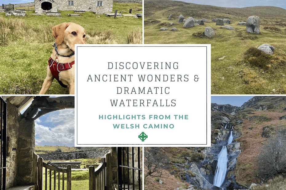
We visited the old church in Llangelynin on stage 6 of the Welsh Camino. Departing from Rowen, we turned right and walked a steep climb through the woods along the Coffin Path until we reached this ancient little church. It is known for being one of the oldest churches in Wales that is still in regular use.
The church is situated on a hilltop overlooking the Conwy Valley, and it is believed to have been founded in the 12th century. It is constructed of stone and slate, with a simple, rectangular nave and a small, square tower. The interior of the church is plain and unadorned, with whitewashed walls and a wooden roof. It has a peaceful and tranquil atmosphere that is perfect for quiet reflection and contemplation.


During the 19th century, a parish church was built in nearby Rowen which was comparatively more accessible. However, this church was shut down in the 1980s while the Llangelynnin Old Church persevered and is still used for regular worship. It attracts a diverse congregation of walkers and pilgrims on Easter morning. It also hosts weddings, baptisms, and even the ordination of priests in its unique setting.
Walking around the walled churchyard, we came across a small well associated with Saint Celynnin, a 6th century saint after whom this church was named. Its waters were reputed to have power to heal children.
The stunning landscape of this remote site, coupled with its panoramic views, have made it a popular stop for pilgrims on their way to Bardsey Island, and an integral part of many other local walking routes.
Penmaenmawr Stone Circles

Leaving the Old Church, we followed the track going uphill on to the open countryside which offered panoramic views over Conwy Valley, Conwy Town, and Conwy Castle. The stone circles are found perched on the hill top above the town of Penmaenmawr.
The Penmaenmawr Stone Circles are thought to date back to the Bronze Age, around 4,000 years ago. The site consists of three separate circles, each made up of large standing stones. The largest of the circles has a diameter of approximately 40 meters and contains 32 stones, while the smallest circle is only around 8 meters in diameter and has just 9 stones.
They are believed to have been used for ritual or ceremonial purposes related to celestial events such as the solstices or equinoxes. Archaeological excavations at the site have uncovered evidence of cremations and other ritual activities, suggesting that the site was considered to be a sacred place. The circles are also part of a larger network of megalithic sites in the area, including the nearby Druid’s Circle, which is another impressive example of Bronze Age architecture.
We couldn’t stay at this site for very long because the weather suddenly turned and rain started pouring down heavily accompanied by strong winds! From the stone circle, the path joined with the North Wales Path (NWP) and the Wales Coast Path until the Wales Coast Path splits off to the right to go down to Llanfairfechan. Staying on the NWP, we entered the Nant y Coed Nature Reserve, crossing a stream (pictured below) before steadily walking uphill following the Roman Road. Here we came across ponies lazily grazing in the lush meadows. We continued following the Roman Road until we reached the village Abergwyngregyn.


From high above the hill here we could see the Menai Strait and Puffin Island.
Aber Falls

From the Abergwyngregyn car park (love typing that name), we followed the sign “Waterfalls” for 2 km. The waterfall is fed by the Afon Goch river and drops approximately 120 feet into a plunge pool below. I loved dipping into the cold water here, even in February, so refreshing! Mommy came prepared with a towel to dry me off afterwards.
From the waterfalls, we continued to follow the NWP to pass another smaller waterfall before climbing slowly until reaching the summit with wide views over Ynys Mon, the Great Orme and beyond. We had a lovely picnic lunch here.


Starting from Flintshire and passing through historic villages and churches, the topography was now changing as we neared the Snowdonia mountain range. The next few stages of the Welsh Camino will skirt around the Snowdonia mountain range including a stop at Llanberis. Finally the last stretch of the Camino moved towards the coast line and we rejoined with the Wales Coast Path for the last 3 days until we reached Aberdaron.

